


Eddystone 🇺🇸
-
Nautical Twilight begins:04:53 amSunrise:05:58 am
-
Sunset:07:58 pmNautical Twilight ends:09:04 pm
-
Moonrise:03:37 am
-
Moonset:02:49 pm
-
Moon over:09:13 am
-
Moon under:09:26 pm
-
Visibility:26%
-
 Waning Crescent
-
Distance to earth:363,640 kmProximity:98.7 %
Moon Phases for Eddystone
-
good Day
-
minor Time:02:37 am - 04:37 am
-
major Time:08:13 am - 10:13 am
-
minor Time:01:49 pm - 03:49 pm
-
major Time:08:26 pm - 10:26 pm
Tide Clock
Tide Graph
Times
| Tide | Time | Height |
|---|---|---|
| low | 03:32 am | 0.92 ft |
| high | 08:50 am | 6.23 ft |
| low | 04:13 pm | 0.69 ft |
| high | 09:29 pm | 6.04 ft |
| Date | Major Bite Times | Minor Bite Times | Sun | Moon | Moonphase | Tide Times |
|---|---|---|---|---|---|---|
|
Fri, 03 May
|
08:13 am -
10:13 am
08:26 pm -
10:26 pm
|
02:37 am -
04:37 am
01:49 pm -
03:49 pm
|
R: 05:58 am S: 07:58 pm |
R: 03:37 am S: 02:49 pm |
Waning Crescent |
low: 03:32 am
, 0.92 ft
high: 08:50 am
, 6.23 ft
, Coeff: 122
low: 04:13 pm
, 0.69 ft
high: 09:29 pm
, 6.04 ft
, Coeff: 116
|
|
Sat, 04 May
|
09:03 am -
11:03 am
09:15 pm -
11:15 pm
|
03:03 am -
05:03 am
03:04 pm -
05:04 pm
|
R: 05:57 am S: 07:59 pm |
R: 04:03 am S: 04:04 pm |
Waning Crescent |
low: 04:35 am
, 0.75 ft
high: 09:50 am
, 6.27 ft
, Coeff: 123
low: 05:07 pm
, 0.59 ft
high: 10:23 pm
, 6.4 ft
, Coeff: 127
|
|
Sun, 05 May
|
09:53 am -
11:53 am
10:06 pm -
12:06 am
|
03:27 am -
05:27 am
04:19 pm -
06:19 pm
|
R: 05:56 am S: 08:00 pm |
R: 04:27 am S: 05:19 pm |
Waning Crescent |
low: 05:35 am
, 0.56 ft
high: 10:46 am
, 6.27 ft
, Coeff: 123
low: 06:00 pm
, 0.49 ft
high: 11:15 pm
, 6.73 ft
, Coeff: 138
|
|
Mon, 06 May
|
10:44 am -
12:44 pm
10:59 pm -
12:59 am
|
03:53 am -
05:53 am
05:35 pm -
07:35 pm
|
R: 05:55 am S: 08:01 pm |
R: 04:53 am S: 06:35 pm |
New Moon |
low: 06:33 am
, 0.39 ft
high: 11:40 am
, 6.23 ft
, Coeff: 122
low: 06:50 pm
, 0.49 ft
|
|
Tue, 07 May
|
11:38 am -
01:38 pm
11:22 pm -
01:22 am
|
04:22 am -
06:22 am
06:54 pm -
08:54 pm
|
R: 05:54 am S: 08:02 pm |
R: 05:22 am S: 07:54 pm |
New Moon |
high: 12:05 am
, 6.96 ft
, Coeff: 146
low: 07:28 am
, 0.3 ft
high: 12:31 pm
, 6.14 ft
, Coeff: 119
low: 07:39 pm
, 0.52 ft
|
|
Wed, 08 May
|
12:12 am -
02:12 am
12:32 pm -
02:32 pm
|
04:54 am -
06:54 am
08:11 pm -
10:11 pm
|
R: 05:53 am S: 08:03 pm |
R: 05:54 am S: 09:11 pm |
New Moon |
high: 12:53 am
, 7.05 ft
, Coeff: 149
low: 08:21 am
, 0.3 ft
high: 01:22 pm
, 6 ft
, Coeff: 115
low: 08:28 pm
, 0.66 ft
|
|
Thu, 09 May
|
01:05 am -
03:05 am
01:29 pm -
03:29 pm
|
05:34 am -
07:34 am
09:25 pm -
11:25 pm
|
R: 05:51 am S: 08:04 pm |
R: 06:34 am S: 10:25 pm |
New Moon |
high: 01:41 am
, 7.02 ft
, Coeff: 148
low: 09:12 am
, 0.36 ft
high: 02:12 pm
, 5.84 ft
, Coeff: 109
low: 09:15 pm
, 0.79 ft
|


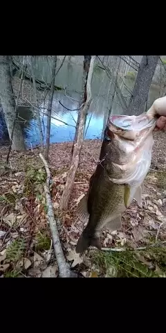
uploaded by: Mick.e

uploaded by: Mick.e

uploaded by: Mick.e

uploaded by: PT Edward fisher

uploaded by: PT Edward fisher

uploaded by: Andretheone

uploaded by: John Needham

uploaded by: Lee Smith 1

uploaded by: D2Turnt

uploaded by: PT Edward fisher
Best Fishing Spots in the greater Eddystone area
Wharf's or Jetties are good places to wet a line and meet other fishermen. They often produce a fresh feed of fish and are also great to catch bait fish. As they are often well lit, they also provide a good opportunity for night fishing. There are 1 wharf(s) in this area.
Springers Wharf - 10km
We found a total of 98 potential fishing spots nearby Eddystone. Below you can find them organized on a map. Points, Headlands, Reefs, Islands, Channels, etc can all be productive fishing spots. As these are user submitted spots, there might be some errors in the exact location. You also need to cross check local fishing regulations. Some of the spots might be in or around marine reserves or other locations that cannot be fished. If you click on a location marker it will bring up some details and a quick link to google search, satellite maps and fishing times. Tip: Click/Tap on a new area to load more fishing spots.
Chester Island - 2km , Monds Island - 3km , Aunt Debs Ditch - 4km , Old Canal - 4km , Thompson Point - 4km , Crab Point - 5km , Raccoon Island - 5km , Sand Ditch - 5km , White Sluice Race - 5km , Little Tinicum Island - 5km , Long Point - 5km , Mill Dam - 5km , Pa-219 Dam - 5km , Bramell Point - 7km , Cooper Lake - 7km , Greenwich Lake - 7km , Big Thoroughfare - 7km , Crum Creek Dam - 7km , Hay Island - 7km , Little Thoroughfare - 7km , Smith Island - 7km , Birch Creek - 8km , Phillips Pond - 8km , Broomall Lake Dam - 8km , Broomalls Dam - 8km , Calcon Hook (historical) - 8km , Rockdale Dam - 8km , Tinicum Island (historical) - 8km , Cotton Mill Dam - 9km , Kent Dam - 9km , Plant Number Three Dam - 9km , Naamans Bridge - 10km , Hendrickson Mill Dam - 10km , Lodge Point - 10km , Springers Wharf - 10km , Warrington Mill Dam - 10km , Hog Island - 10km , Lenni Dam - 10km , Llewellen Mill Dam - 10km , Province Island - 10km , Geist Storage Dam - 11km , Main Ditch - 12km , Harkness Point - 12km , Naylors Run Dam - 12km , Pa-237 Dam - 12km , Yankee Point - 12km , Platt Memorial Bridge - 12km , Narraticon Lake Dam - 13km , Washington Point Neck - 13km , Brinton Lake Dam - 13km , Gibson Point - 13km , Girard Point - 13km , Girard Point Bridge - 13km , Red Bridge - 14km , White Bridge - 14km , Concord Mills Dam - 14km , Millbourne Dam - 14km , Point Breeze - 14km , Reserve Basin - 14km , Bellevue Lake Dam - 15km , Lake Basgalore - 15km , Bell Lake - 15km , Eagle Point - 15km , Jeesups Mill Lake - 15km , Oldmans Point - 15km , Meadow Lake - 15km , Greenwich Island - 16km , University Avenue Bridge - 16km , Trout Lake Dam - 16km , Howell Cove - 16km , Woodbury Creek Dam - 17km , Brinton Lake - 17km , Centennial Lake - 17km , Concourse Lake - 17km , Earles Lake - 17km , George H Earle Junior Dam - 17km , Green Countrie Dam - 17km , Porches Mill Dam - 18km , Columbia Bridge - 18km , Fairmount Dam - 18km , Girard Bridge - 18km , Lake Lenape Dam - 18km , Girard Avenue Bridge - 18km , Comeys Lake - 19km , Greenes Lake - 19km , Ridley Creek Dam - 19km , Griscom Dam - 19km , Register Dam - 19km , Sinkler Dam - 20km , Helms Cove - 20km , Carneys Point - 20km , Strawberry Bridge - 20km , Westtown Dam - 20km , Dove Lake - 20km , Dove Lake Dam - 20km , Mill Club Dam - 20km , Morris Estate Dam - 20km , Sinott Dam - 20km
Comments